Pecos River Texas
The Pecos River Texas's headwaters actually don't originate in Texas. But flow from north of Pecos, New Mexico, in the Eastern Sangre de Cristo Mountains.
From there it flows from over 12,000' elevation, more or less downhill about 926 total miles. Until its outlet near Del Rio TX at the Rio Grande River. When it's then under 1000' elevation.
With purchases made via links on our site, we may earn a small commission at no extra cost to you. Details at our Advertising Policy.
It enters Texas from New Mexico at NM's lowest point.
The two states create a large reservoir on the border, but the majority is within Texas. We'll let you in on the Pecos River in Texas flowing details. Including this Pecos River with-in Texas Map.
Pecos River Map

Pecos River in Texas
Another Texas River with historic lore. From Pecos Bill to Judge Roy Bean, the law West of the Pecos. Have you heard any of its stories?
Red Bluff Reservoir
When the Pecos River enters Texas from New Mexico, it's at this shared reservoir...
Red Bluff Reservoir - Overwhelming the majority of its waters are in Texas. One lone facility is the boat ramp at the very south end. The dam is just east.3
It's a rare oasis in a very dry area. Going here for recreation, you can consider it a gem in the rough!

Pecos River Texas Flowing Southeast
The Pecos River, Texas side, exits via Red Bluff Dam, and heads southeast.
It winds & winds through Texas desert lands. Passing some oil wells, gravel pits, mining areas. Plus a little farming & lots of desolation.
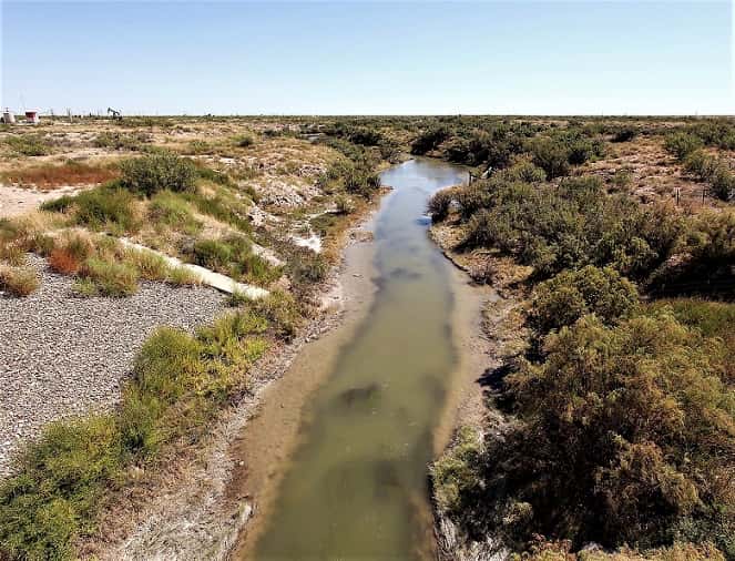
The river through here suffers from hard times.
As you may notice. It's fairly obvious viewed in Grandfalls TX. There it runs under Crane County Hwy.11. That's just northwest of the Old Grand Falls Highway intersection.
Juan Cordona Lake
Follow its undulating path further. At a point, if you look northeast, you'll find an odd lake formation...
Juan Cordona Lake - Its historic marker is in Crane TX, even further northeast from the lake.
- Named [sic] for Juan Cordova, who originally owned the lands here.
- It's a natural salt lake area.
- Waters often & variably dry up. Which enables salt to takers since at least the 1600s. The time when Apaches lived here.

Soon the Pecos River's surrounding terrain becomes a little more mountainous. With mesas & tablelands. Then some hilly desert.
But still desolate.

The Pecos River winds under U.S. Hwy.385 in Girvin Texas. Driving there, have you ever noticed the adjacent Rio Pecos RV Park/Campground? It closed just past 2022's start. Will it reopen? On this vast wilderness of exploration, it would be handy!
Twisting through miles & miles more of West Texas emptiness. Occasional canyons, country & farm roads.
Then rolling east of Iraan Texas.
Where Rancher Ira (and wife Ann - so the name: IraAn) discovered oil.
Was a boomtown for awhile. Later oil production dwindled, as did the populace. Population now around 1200.
The Pecos rolls under Hwy.190 east of town.

Pecos River Pandale Crossing
The Pecos River in Texas now parallels swervingly east of Rt.349. Going south to flowing under I-10, east of 349's #325 Entrance to the freeway.
Wandering east of Sheffield TX, near farming areas. Crossing under Pecos County Hwy.290.
Then through some canyon country.
Til finally just Southwest of Pandale, the Pecos River flows under Langtry Rd., at Big Fielder Draw.
Nearby is Pandale Crossing River Resort (432-940-5643) with camping, a few RV sites & cabin rentals.
Before long on its generally southerly course, Texas's course for the Pecos River flows east of Langtry & nearly parallels state Hwy.90. That highway nearly parallels the U.S./Mexico Border.
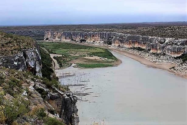
This southernmost end of the Pecos River in Texas, is probably where you can more beneficially enjoy this waterway. As we think it's the BEST PARTS of the Pecos River, Texas...
- Pecos River Bridge - East of Langtry, West of Comstock; between the two you'll cross this bridge over the river's gorge. You'll drive along the highest TX bridge via a highway. About 270' above the Pecos, depending on changing water levels.1

For stunning views, stop-over here:
Exit Southeast Side - Onto Park Rd.67. It takes a rough downhill trek to a "Rest Area." Really a picnic spot, no rest-rooms.
- What would you want to stop here for? The overlook into the gorge. The best views are here! The Pecos River (There at sunset? You'll love it!), the bridge, the canyon.
- If you have train interest, something more outta site, upstream, around the bend...
- Pecos High Bridge - AKA, Pecos Viaduct. A railroad bridge, when finished in 1892, then the highest bridge in the U.S. An engineering amazement for its time. A bridge watchman worked full time when trains began crossing regularly.
- Refurbished with reinforcements in 1910 & 1929.
- Then during WWII, a new one was built. The old one remained temporarily as a stand-by.
- By 1950 it was dismantled & its parts delivered - where? Two Tales exist. The new train bridge is still in use!
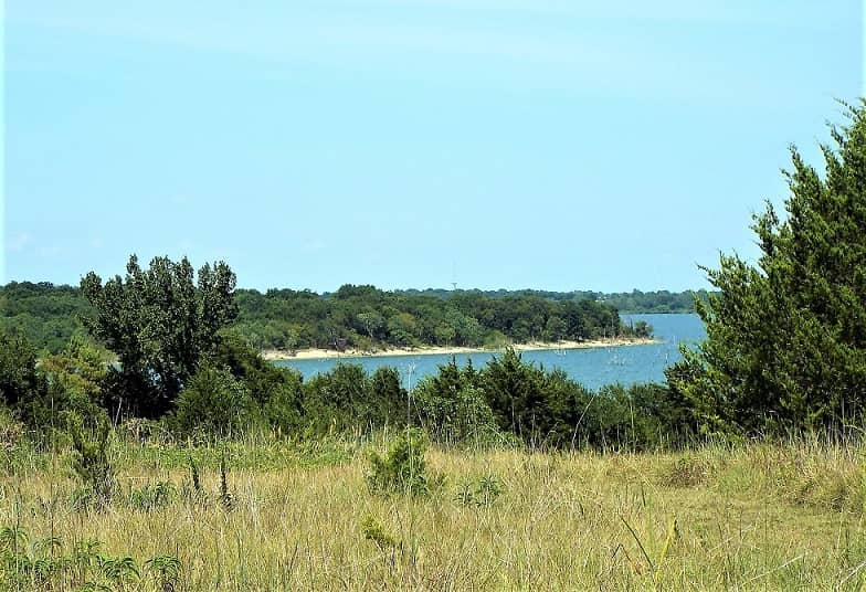
Amistad Reservoir
Just beyond this location, the Pecos River in Texas widens out to become the International Amistad Reservoir.
Amistad is an international reservoir because it encompasses the US/Mexico border's historic channel of the Rio Grande. Amistad is Spanish for "friendship."3
Once the Pecos flow enters the Rio Grande. They merge a little over 1 mile west of the Pecos River Bridge.

Park details2...
- You can access it on the South Side. And view it live now via the webcam at the Boat Ramp!
- Campsites are 1st-come/1st-served. No hook-ups among 5 sites. A dump station & drinking water are on the Diablo East boat ramp road.
- Lots of boating variety.
- The Rio Grande park boundary continues 74 miles up the Rio Grande. Plus there's 25 miles of Devils River in addition to the 14 Pecos miles.
- Amidst all this are tons of coves to explore.
- Excellent fishing, so bring your gear!
- Get all updated info, including boat pass details, call the Visitor Center: 830-775-7491.

Other Suggestions For You:
Texas Trinity River - See Where It Goes!
Texas Trinity River is a major water source for the state. Lakes provide fishing, boating, camping & lots of family fun. Follow its course, we'll show the way.
Beautiful Lakes in California - You Want 'Em
Beautiful lakes in California are in every corner of this huge state. Wherever you plan to be, find gorgeous lakes for recharging your nature's spirit!
Best Lakes in Oklahoma - Choose Your Locale
Best lakes in Oklahoma are throughout the entire state. You can roam all over, or concentrate on the area that suits you best in your travels.


See References For Pecos River Texas>
Some Directional Information on This Page May be sourced from Map data ©Google
If You're Enjoying This - Please Pay it Forward
Send It/Share It

We're From Arizona & We Know Our Southwestern Home
We Love Helping Others Appreciate It Too!
Supporting Local Businesses Throughout the Southwestern USA
Privacy Policy | Terms/Conditions/CC Licenses | Advertising Disclosure | Contact Us
© SWlakesUSA.com: 2021-2022 - A Production of Picture Rocks Networking LLC | All Rights Reserved
As an Amazon Affiliate we earn from qualifying purchases.
WE DO NOT SELL ANY PERSONAL INFORMATION FROM THIS WEBSITE
This site is protected under U.S. and International copyright laws. Do Not Copy - No use is permitted without permission.

